Showing posts with label mapping. Show all posts

Saturday, 9 July 2011

Offline mapping for fieldwork? - Google Maps for Android

For many years now I have been using and advocating offline mapping software for fieldwork in technology enhance learning applications. This is software that does not rely on any internet connection and allows the user to add their own maps in GPS based applications. Why? Well there are many occasions that using a map in a remote location becomes an issue because there is no data connection. The reality is that if anything is going to hinder students learning, it's waiting for a map to load...

So I was very very pleased to find that 'Google Maps for Android' are now allowing several square mile sections of maps (as explained in this article) to be saved on your mobile device. At the moment I have no idea how well this will work, as its only just been released. But this is how it works for those interested in trying:
  • Update your Google Map to the latest version.
  • Open 'Maps' on your android device > press Menu > More > Labs (Labs are test area for applications Google are experimenting with) > Download map area
  • Once active simply click and hold in a central point of your chosen location
  • Open the icon that appears and select the bottom option 'Download map area'
  • It will show it is downloading and then a black square border will appear showing the area that is saved to your device. It should still show your map with both data and Wifi turned off!
Sadly it only downloads basic road maps, so no satellite maps available (but its a fantastic start!) Lets hope this trend moves onto the other mapping services such as the excellent educational sources provided by Edina. This could really help education for many science and technology based fieldwork locations here at Plymouth University!

Google if you're listening, the ability to download satellite maps or even to use my maps (my spaces) with way-points etc included would be fantastic!

Friday, 8 July 2011

Geospatial Focus Group


Today I attended the first Geospatial Focus Group here at Plymouth University. Anne Mather an Associate Professor (Reader) in Physical Geography, School of Geography, Earth and Environmental Sciences (Faculty of Science and Technology) came up with the idea to combine ideas, knowledge and data with a range of individuals both internal and external of the the Faculty. The topics ranged from the following (Plymouth University staff):

Tim Absalom (Geography, SoGEES). Digimap
Richard Hartley (Geography, SoGEES) Hardware and software available for collecting and manipulating Geospatial data in Geography.

GIS resources in teaching/research (with emphasis on the cheap and simple!):
Victor Abbott (Marine Science and Engineering) Hydrographic survey
Sarah Boulton (Geology, SoGEES) River Tools
Martin Stokes (Geology, SoGEES) Landserf
Anne Mather (Geography, SoGEES) Google Earth

Also included were guest presentations in the use of Geospatial data beyond education, both extremely interesting. Thank you to both speakers!:
Commander Andrew Swain (FOST HM), Devonport

A very large array of topics. I'm always amazed how all these areas overlap in terms of how they recorded and publish data. Of course, from a learning technologist perspective I was rather keen to see how staff used their geospacial resources for teaching, meetings like this are invaluable for getting an idea of what your clients may ask you in the future!

Keith Westhead briefly introduced the very handy and excellent iGeology mobile application that is available for both iPhone/Pad and Android devices. This software relies on pulling down their geological map via a 3G data connection or similar in relation to the GPS location provided by the mobile device. As long as you have a fast data connection it works brilliantly. Having had some difficulty using any data derived mapping system such as this in 'very' remote locations, I asked if they were planning to make cached or small maps tiles available to download for use offline (contained within the programme, to ensure copyright issues). Apparently they have not, but he said that this was a good idea and would take this back to BGS and the software developers as a possible feature. I hope that they do! there is a lot of scope for such functionality in fieldwork.

Digimap aside, the availability of 'digital maps for mobile devices' (in education contexts) could be an option, so educational software developers can incorporate these maps into their own digital training material. Ideas like these are out of our hands but hopefully organisations such as BGS will consider the wider marketing advantage and offer such services.

Cdr Andy Swains presentation, on the Royal Naval approach to using hydrographic mapping and land surveying was very interesting (we are talking life and death situations! The data has to be good!), its fascinating how different organisations utilise technologies for their benefit.

A great set of talks from everyone, I will certainly be looking forward to the next meeting.

Wednesday, 23 February 2011

Peer Assisted learning using PDAs moves to Coverack geology fieldtrip


View Coverack (PDAs) in a larger map - N.B. a few icons have photos (select to view)

I have been working on another project (similar to the Kingsands geology fieldwork) with Dr Meriel Fitzpatrick and Dr Mark Anderson utilising GPS enabled PDAs, its a mobile assisted teaching resource for geology students. This time the location is a coastal village called Coverack in Cornwall (UK), unlike Kingsands which was a small section of beach north of Kingsands. This location covers over half a mile, as shown on the map from point 1 to 7. A few of the site locations have images of the PDAs being tested, click to show. A larger map view is recommended in order to view these photos. The blue line is where I was wandering between sites 3 and 7 during some opportune testing, but give some idea of how the devices are used as participants move between the sites.

This project received a teaching and learning fellowship in 2010, and is now flourishing into a working educational resource. Thanks also go to Tom Shelmerdine who also helped to gather a construct a lot of the data used in this resource.

This noble fieldwork resource will be tested with students in the latter part of March 2011.

More details available on the PedRIO database

Thursday, 21 October 2010

Using Google Earth to train engineering geologists

I have recently had the pleasure of working on this geology based technology enhanced learning (TEL) project with Prof. Jim Griffiths (Head of the School of Geography, Earth, & Environmental Sciences, University of Plymouth), Dr Anne Mather (University of Plymouth) and Professor Adrian Hartley (School of Geosciences, University of Aberdeen), a project originally funded by the Experiential Learning CETL here at Plymouth.


The project was primarily about using technologies to help engineering geologists better understand such things as landscapes and how processes of landforms develop over geological time. The approach chosen by Prof Griffiths and colleagues was to implement Google Earth for reconnaissance mapping and terrain evaluation training. We essentially used Google Earth's excellent layering ability to produce geomorphological layers coupled with appropriate integrated legends, image pop-ups and tours. The beauty of Google Earth from teaching enhanced learning perspective, is that it's free; easy to navigate; provides really quite decent terrain and outputs are easily packaged into KMZ files for distribution among students. Students can easily do a reconnaissance of entire massive landforms with relative ease, in this case the well known great landslides of Chile, obtaining a much clearer understanding of the environment. It's not a replacement for the real thing, but an excellent addition to the training required to bring students to chartered geologist level and certainly something we will be looking to develop further in the future.

Further information:
Griffiths, J.S., Mather, A.E., Truscott, J.B., & A. Hartley (2010) Application of low-cost satellite imagery for reconnaissance mapping and terrain evaluation training: A case study of coastal landslides, Chile. Geologically Active: Proceedings of the 11th IAEG Congress. Auckland, New Zealand, 5-10 September 2010. 

Currently available from Amazon,  Routledge Taylor & Francis Group or ISBN: 978-0-415-60034-7.

Friday, 16 July 2010

Google App Inventor for Android

Im keeping a keen eye out on mobile devices software that have some educational potential and functionality that relate to the science and technology disciplines and could be made freely available to students. Google have now released an application 'inventor' for its android based phones. Its esentially a way to write your own 'Apps' without actually getting involved with the nitty gritty of hard core programming. Its very much a visual programming language. I think their video says it all, with a basic example.


For me the bit Im excited about is that to quote Google:

"...App Inventor provides access to a GPS-location sensor, you can build apps that know where you are. You can build an app to help you remember where you parked your car, an app that shows the location of your friends or colleagues at a concert or conference, or your own custom tour app of your school, workplace, or a museum."

A piece of free software that allows access to the GPS is good news for field work as far as Im concerned. It will be interesting to see how good this software is...

Creating your own Google My Maps


I have been working on a number of Google Map related teaching and learning projects recently and have used Google Maps to good effect within web pages for a number of my projects. Previously this process required some javascript added to the web page code, of course there are occasions more complicated applications will requires these maps to be hard coded... however, My Maps has been coming along in leaps and bounds and negates a lot of this process altogether. It even creates the necessary embedding code for you!

You will need to create a Google account to use this facility, if you already have an iGoogle, then log in with this first. Ok, so you're logged and on the My Maps page, what next? The above video by Google explains the process very well and those of you that use My Maps may have already been greeted with this video. Note in the video that when adding photos, the items must be hosted on the web for example Flickr or Picassa to name a couple. Enjoy your mapping.

Friday, 7 May 2010

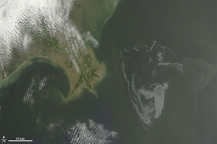
Follow the Gulf of Mexico Oil Spill in Google Earth / Map

I thought I would throw in this post for all those interested in environmental impact/monitoring. Google has put up a very good resource on the Gulf of Mexico Oil Spill showing both satellite and drawn imagery on the various stages of the oil spill. It allows users to interactively view elements. Even showing fishing boundaries and how the spill is overlapping those.

It's possible to view this event within a web browser using the more commonly known Google Maps based interface. Those that want more flexibility viewing items may prefer to download files that can be opened in Google Earth these are also available from the oil spill map site.

Just a quick tip, don't forget to turn on the Terrain layer (as shown below). This will give you a near real life interpretation of the terrain.

For serious map users, I will mention that Google Earth Pro is available to university staff. Please register your request with IT support. When you have installed Google Earth Pro, I strongly recommend running the software, going to the help drop down menu in the interface and searching for updates to obtain the latest version.

Satellite image above courtesy of NASA

Wednesday, 3 March 2010

Bing ...Augmented reality maps


Came across this interesting video....'Blaise Aguera y Arcas demos new augmented-reality mapping technology from Microsoft.' Flickr photos are layered onto the 3D street views provided by Bing, with some very spectacular results. Could have some useful applications in education.

Microsoft Bing maps and you will need the Silverlight plugin for it to work.

I discovered that it currently only works in certain locations that allow street level navigation. Once the Silverlight is installed, try the working examples of this augmentation on Bing maps for San Fransisco etc first.

Augmented reality - according to wikipedia...

Sunday, 10 January 2010

Peer Assisted Experiential Learning (PAEL) in Earth Sciences presented at GEES event


The above slides were presented at the GEES Geoscience student learning event 'Overcoming Barriers to Learning in the Geosciences', Wednesday 20th January 2010, Aston Webb building, University of Birmingham.

Providing details on how the PDA rescource was developed and feedback from the student experiences.