Showing posts with label GEES. Show all posts

Thursday, 21 October 2010

Using Google Earth to train engineering geologists

I have recently had the pleasure of working on this geology based technology enhanced learning (TEL) project with Prof. Jim Griffiths (Head of the School of Geography, Earth, & Environmental Sciences, University of Plymouth), Dr Anne Mather (University of Plymouth) and Professor Adrian Hartley (School of Geosciences, University of Aberdeen), a project originally funded by the Experiential Learning CETL here at Plymouth.


The project was primarily about using technologies to help engineering geologists better understand such things as landscapes and how processes of landforms develop over geological time. The approach chosen by Prof Griffiths and colleagues was to implement Google Earth for reconnaissance mapping and terrain evaluation training. We essentially used Google Earth's excellent layering ability to produce geomorphological layers coupled with appropriate integrated legends, image pop-ups and tours. The beauty of Google Earth from teaching enhanced learning perspective, is that it's free; easy to navigate; provides really quite decent terrain and outputs are easily packaged into KMZ files for distribution among students. Students can easily do a reconnaissance of entire massive landforms with relative ease, in this case the well known great landslides of Chile, obtaining a much clearer understanding of the environment. It's not a replacement for the real thing, but an excellent addition to the training required to bring students to chartered geologist level and certainly something we will be looking to develop further in the future.

Further information:
Griffiths, J.S., Mather, A.E., Truscott, J.B., & A. Hartley (2010) Application of low-cost satellite imagery for reconnaissance mapping and terrain evaluation training: A case study of coastal landslides, Chile. Geologically Active: Proceedings of the 11th IAEG Congress. Auckland, New Zealand, 5-10 September 2010. 

Currently available from Amazon,  Routledge Taylor & Francis Group or ISBN: 978-0-415-60034-7.

Monday, 29 March 2010

Devon Great Consuls...Entering a new ERA (Enabling Remote Activity)


View Devon Great Consuls in a larger map


I visited Devon Great Consuls (near Tavistock, Devon) today with Dr John Maskall (University of Plymouth), Dr Trevor Collins (Open University/Knowledge Media Institute, JISC Portable VoWLAN project) and John Lea (JISC Portable VoWLAN project Consultant). This project is linked to the ERA (Enabling Remote Activity) project. More details about the Consuls can be found on the virtual tour.


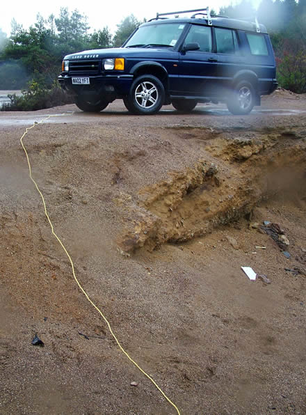
We were essentially testing Trevor's highly portable wireless communications network for use in the up and coming GEES conference in July (Geography, Earth and Environmental Sciences - Subject centre). Dr John Maskall teaches Environmental Science at this location and wanted to utilise some technology to aid learning and enhance accessibility. In the photos above (left to right): Plymouth University SoGEES's Land Rover - note network cable which was trailing to the antenna, Trevor (yellow safety jacket) and John Maskall who is wearing the communication headset. John Lea, was briefly enjoying the dry of the Land Rover, but not for long... Yes it was raining, but this did not spoil the experience! And before you ask, yes I had a go too and we all got soaked - in full weather gear or course ;)

Trevor and John Lea's set up consists of a home WiFi, network switch, batteries galore! loads of network cables, antenna, digital camera, video camera and number of portable Asus Eee PCs...

One of these PCs is used as a server, and the other two as clients. Both clients are used to communicate between the based server (in this case, one in the Land Rover). The 'roaming client PC' (Photo left: rucksack on John Maskall's back) communicates voice, and in addition digital photographs and video to the other user in the Land Rover. For the techys reading this, there are more details on the equipment and software used on the ERA wiki!

What struck John M and I immediately was how smooth the video and clear the voice communication was. (Photo right: video showing an Asus Eee PC - network cables dangling) The only real issues on this day were the occasional WiFi blind spot and keeping the lens free from rain! But this is exactly why its important to field test technology so we could iron out the bugs and improve for future deployment.


The antenna is shown on the far left (Photo left) with an additional fixed WiFi IP camera on the right (Photo left) which was displaying the whole of the consuls continuously. The blue bag actually contains the battery. Note that the yellow cable is the one trailing to the Land Rover which of course connects to the server within.

This antenna is the main communication link with the roaming unit (in this case John Maskall) No pun intended John... Considering that the main equipment is predominantly home WiFi equipment, it was extremely effective.
John Maskall was able to talk about the site while showing video, and I was able to also ask John to look at or describe specific items on the site as he roamed. I think you can start to see the benefits of such a setup.

I should explain that the Google 'My Map' above shows the areas in which we tested the unit (red lines) and the points are merely points of interest. Point 15 (blue flag) is where the antenna was located. The little blue truck is where the Land Rover was placed. You will need to zoom ('+') on the map near the very top points to view the icons clearly.

All in all an excellent day in the field, many thanks to Trevor and John Lea for making this a successful day and letting John Maskall and I really test the equipment to its full!

Trevor has posted more photos and a video on his blog.

Thursday, 21 January 2010

Peer Assisted Experiential Learning (PAEL) in extending fieldwork practice in the Earth Sciences

I have been working on a project with Dr Mark Anderson & Dr Meriel Fitzpatrick, as part of the Experiential Learning CETL. In this project we enhance PAEL using PDAs loaded with the MScape software.
Our experiences and findings have been recently presented at the GEES 2010 conference 'Overcoming Barriers to Learning in the Geosciences', University of Birmingham.

Further details are available from the abstract. However in a nutshell, we are using Trimble Juno SC PDAs with the latest version of MScape software installed. The PDAs are GPS enabled so ariel maps can be programmed with automatic prompts when students enter specific locations of interest. Students entering these 'zones' are prompted to carry out specific tasks or observations, that enable a better inderstanding of the surrounding geology.

Sunday, 10 January 2010

Peer Assisted Experiential Learning (PAEL) in Earth Sciences presented at GEES event


The above slides were presented at the GEES Geoscience student learning event 'Overcoming Barriers to Learning in the Geosciences', Wednesday 20th January 2010, Aston Webb building, University of Birmingham.

Providing details on how the PDA rescource was developed and feedback from the student experiences.